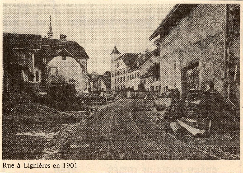
Lignières: Then and Now |
Click image for contemporary view.
The historical photograph is courtesy of M. Werner Löffel of Lignières, who kindly contributed images of his post card collection to the archives of the Fondation de l'Hôtel de Commune de Lignières.
by John Walker May, 2007 |
|
Walking along the Rue du Franc-Alleu from the fromagerie toward the centre of the village, we come around a bend and see the Hôtel de Commune (Place du Régent 2, RACN 010-6456-00064) with its distinctive tower at the end of the street. To the left, the more spindly bell tower of what was then the schoolhouse and is now the Maison de Commune (Place du Régent 1, RACN 010-6456-00076) peeks above the peak of the roof in the “then” picture. This distinctive landmark is no more, and only the air raid siren (against a contingency few envisioned when the “then” picture was taken in 1901) pierces the skyline today.
Since we're standing here in the middle of the Rue du Franc-Alleu, a few words are in order about the origin of the curious street name, which is likely to elicit a reaction of «Quoi?» even from fluent speakers of French. Lignières is situated at the boundary of three states dating from the middle ages: the domain of the Bishop of Basel, the Republic of Berne, and the territory of the Count of Neuchâtel. On September 22nd, 1535, the boundaries were defined by a tribunal and stones placed to mark the frontiers. The residents of Lignières, however, traditionally had grazing rights for their livestock which crossed the new village boundary, and to respect these, it was shifted to the east. Unfortunately, this allowed the animals of Lignières and those of residents of the adjacent village of Nods to transmit epidemics to one another, so eventually a sanitary barrier was established along a hedgerow named «la haie de contagion», which was later marked by stones between 1556 and 1613. This was codified officially in a treaty signed June 20th, 1705, which sorted out the rights of the three states to the one by four kilometre band of territory between the two lines of stones. According to this agreement, territory within this zone was exempt from the traditional rights of the sovereign, in particular the “lods”, or tax on the transfer of property. The word “alleu” is derived from the old French “alôd”—a territory owned outright, exempt from feudal obligations such as the lods, and hence “franc-alleu” is a territory exempt from these impositions by the state. Nothing is as offensive to a state as individuals being exempt from its power, so it wasn't long until the first of many attempts were made to do away with the franc-alleu. No less than the Congress of Vienna, convened to sort out the map of Europe after the defeat of Napoléon I, launched the first assault, mentioning Lignières by name in Article 76; the principality of Neuchâtel chose not to comply. Subsequent abolition attempts were launched in 1842–1843, after the revolution of 1848, in 1888, and in 1920. The sovereign state finally vanquished the franc-alleu in a law adopted on November 20th, 1991, which went into effect on the first day of 1992. Only the street signs remain.
The building in the foreground at the right (Rue du Franc-Alleu 7, RACN 010-6456-00033), like most of those in this picture, was spared by the fire of 1832. Only the barn (now converted into a dwelling) is visible from this location; the attached farm house is out of the frame to the right. One of the buildings on the left side of the street, mostly out of view in the “now” picture behind the blockish light pink structure, has a lintel above the door which appears to bear the date 1709. Unambiguously dated is the remarkable fountain (RACN 010-6456-00218) just visible beyond the former barn in the right foreground of the “now” picture (it's in the “then” picture as well if you really know what you're looking for—just a corner can be seen beyond the woodpile).
This fountain, with the date 1750 and compass symbol of Lignières carved in the side (see the inset enlargement in the upper right of the above picture), was fashioned from a single slab of locally-quarried Jura limestone, transported into the village by being rolled on logs. The catch basin and pillar with the water spout are of cement and appear to be of recent construction.
Before taking leave of this quarter of the village, let's take note of another intriguing street name here. Just on the other side of the building at the right (see the map below) runs the Ruelle des Oublis (Alley of the Forgotten). In the 1980s, the residents of this area felt themselves excluded from the political life of the village, which was centred mostly up the hill in the “high village”, and erected a hand-made sign reading «Les Oublis». The name caught on, and when in 1991, for the first time, the streets of Lignières were given official names and the buildings numbered, that's what the sign read.