« March 14, 2018 | Main | April 3, 2018 »
Thursday, March 29, 2018
Earth and Moon Viewer Updated
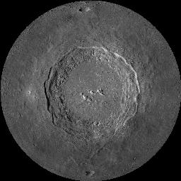
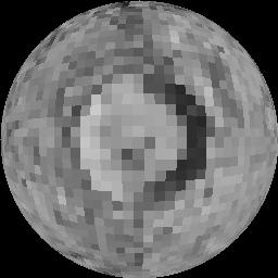
The first major update to Earth and Moon Viewer since 2012 is now posted. Changes in this release are as follows.When viewing the Moon, the default image database is the 100 metre per pixel LRO LROC-WAC Global Mosaic produced by the Lunar Reconnaissance Orbiter Camera Team at Arizona State University from imagery returned by NASA's Lunar Reconnaissance Orbiter spacecraft. This data set provides more than 5700 times the resolution (measured by pixels in the image) of the Clementine imagery previously used (which remains available as an option). Since the complete image database, consisting of 8 bit grey scale values, is 5.6 gigabytes in size, three smaller sub-sampled databases are automatically selected when lower resolution images are required, reserving the 100 metre per pixel data for very close zooms (as low as 1 km), where its full detail is required and only a small portion of the entire database need be brought into memory. You may observe a small pause when displaying images at this resolution. For comparison, below are views of the crater Copernicus from an altitude of 10 km. At left is an image generated from the Lunar Reconnaissance Orbiter data, while at right is the same view generated from Clementine imagery.


- Enabled zooming in as close as 1 km for all image databases which support such high resolution:
- NASA Blue Marble Monthlies (Earth)
- NASA Blue Marble (Earth)
- NASA Visible Earth
- Lunar Reconnaissance Orbiter 100 m (Moon)
- Updated all documents to current Web standards for character set specification in XHTML 1.0 files.
- Updated all documents to use Fourmilab's standard CSS style sheet, justify text, and employ Unicode typography for quotes, dashes, ellipses, and other special characters.
- Upgraded all of the Named Lunar Formations catalogue pages, which were gnarly mid-1990s HTML 3.2 to XHTML 1.0 Strict, with a consistent and much better looking style sheet. The list of Lunar Landing Sites has been updated to add post-Apollo impact and soft landing missions. All links in the catalogues now select the Lunar Reconnaissance Orbiter imagery rather than Clementine.
- The View above Cities page now selects the NASA Blue Marble Monthlies image database.
- The Earth and Moon Map Explorer now uses the NASA Blue Marble Monthlies for the Earth and the Lunar Reconnaissance Orbiter imagery for the Moon.
- Converted legacy .gif images to PNG everywhere (except for a few animated GIFs, for which there is no alternative).
- To support the very large grey scale Lunar Reconnaissance Orbiter image, a new version of the internal Earth Viewer Image Format, EVIF4, has been added. While previous versions of the format supported colour-mapped images with separate day and night imagery (either in the same file: EVIF1 and 2, or in separate files: EVIF3) with 16 bits per pixel, in EVIF4 pixels are 8 bit grey scale values and the night image is synthesised on the fly by shading the pixel values, either smoothly or sharply depending on whether the body being viewed has an atmosphere. While this format is presently used only for the LRO images, it may prove useful for other grey scale data such as radar maps of Venus and Titan. Users may apply gamma correction to images generated from EVIF4 databases to adjust contrast as they wish.
- All documents are now XHTML 1.0 Strict or Transitional, and all have been validated for compliance by the W3C Markup Validation Service.
- A number of stale and broken links have been fixed. All citations of books on Amazon now point to the most recent edition.
- The HTML generated by requests to Earth and Moon Viewer is now XHTML 1.0 Strict and validated for standards compliance. Embedded CSS improves the formatting of result documents.